Showing posts with label Flora. Show all posts

Thursday, June 29, 2023

A Journey To The Enchanting Tawang

Sungester Lake (Madhuri Lake) in Tawang

Sungester was a small lakeside village that was destroyed after a strong earthquake in 1971. The lake remained as its only witness. In the 90s Senior Roshan (Cinema director) decided to shoot a song, 'Tanhai Tanhai' for his film Koyla, at this fitting dream location. Mesmerized by the film's gorgeous heroine Madhuri Dixit, the locals rechristened the lake as Madhuri Lake.
Route Map To Tawang From Guwahati Via Tezpur and Bomdila

Tawang is only 35/37 km from Bum La Pass (la in the local language means pass) which is the nearest pass to the Indo-China border. The nearest major Chinese town Tsona Dzong is 45 km from Bum La.( And I thought China was far :P). To reach Tawang one has to cross one of the highest passes in India - The SE LA PASS at 4170 m above sea level.

LOCATION

Country: India
State: Arunachal Pradesh
Region: Tawang District

MAIN CITIES AND TOWNS (one must be acquainted with, them to plan the itinerary)

1. Guwahati/Dispur, Capital of neighboring state Assam
2. Tezpur, Nearest airport/Heli-ped
3. Bhalukpong, border town (love this name :) - it means where the bear comes to drink water)
4. Bomdila, a local holiday destination, and midway stopover

HOW TO REACH

The nearest big city is Guwahati/Dispur Capital of Assam. Most tourists, begin their Arunachal journey from Guwahati. One can fly or take a train/bus/private/rented vehicle from Guwahati. For Indian nationals as well as foreign nationals, an inner line permit to enter Arunachal Pradesh is a must. The permit is checked at the entry ports. The entry port for the Guwahati Tawang Circuit in Bhalukpong. One can get the permits done at Delhi Arunachal Bhavan, Guwahati Arunachal Bhavan, and Tezpur Arunachal Bhavan. The Guwahati Arunachal Bhavan is at Rukmini Gaon, GS Road. The form for Indian nationals is Rs.5 plus Rs.25 for the inner line permit. Two passport-size photographs and a copy of an ID card/passport are a must. There is a weird rule :P women of all age groups married or single - must bring a 'No objection certificate' from their Father or Spouse or any male guardian. In the absence of either, I have no clue who is supposed to give the so-called NOC. My friend and I found it quite annoying that we couldn't be responsible for our travel plans at our age ( way above 18) :P but alas no arguments with them worked, we had to call our respective fathers and have them speak to the officer at the Bhavan. Men, however, have no such requirements. Talk about gender equality in the 21st century :P.  One gets the permit the next working day. It's a simple process and there is no need to pay extra to the travel agents. For foreign nationals, the fee may be higher. I am not sure!

From Guwahati, there are a few options to reach Tawang.

1. Bikers and those traveling in private/rented vehicles, can follow the route NH 52 till Bhalukpong then take NH 229. It takes around 2.5 hrs to 3 hours to reach Tezpur, then another 5 to 8 hours to Bomdila. The road is pretty good till Tenga Valley. It starts getting closer to Bomdila. It is advisable to stop over at Bomdila or Tenga and start early the next day since the road from Bomdila to Tawang is really unpredictable!!!! If lucky the journey can be completed in 9 hrs. If not, it can take 18 hours or more. We started on an unfortunate rainy day in the month of June and met with two big landslides and scary, slippery, muddy roads. It took us exactly 18 hours to reach Tawang! Hard luck that is! :)

One can start really early from Guwahati, say 3 am, and if all goes well, with no long halts, no bad roads, no rains, and no landslides, one can reach Tawang in 18 to 19 hrs. Well! The mountain roads can get crazy. Therefore, it is better to avoid any risks.

My suggestion would be, to stay at Eagle's Nest camp near Bhalukpong for a day or Tenga or Bomdila and then proceed ahead. Between  Bomdila and Tawang there is just one small village Dirang with limited lodging facilities. 

There are amazing waterfalls right on the road in the stretch between Bhalukpong and Bomdila. We went during the monsoons and were lucky to see them at their full flow but again, if not for the gushing waterfalls, that one can almost stand under, monsoons are not the best time to travel to this part of Arunachal!! 


2. One can also take a helicopter ride from Tezpur to Tawang. It's an irregular service and depends on the weather conditions. Guess one way takes anywhere around 3K - 5K.

3. ONe can opt for a bus from Guwahati which takes around Rs. 170 to Tezpur. Be aware there are two routes to Tezpur, a shorter route that takes 3 hours and a longer route that takes 5 hours or more.  The buses leave from Paltan Bazaar Guwahati, Khanapara Guwahati, and ISBT, Guwahati. Other than buses there are small tempo services which take about the same price. The buses and tempos run throughout the day. There is one bus that leaves at 6am from ISBT which goes directly to Bomdila. 

There is also an early morning bus from Tezpur that goes directly to Tawang. At Tezpur, one can find trekkers/jeeps traveling to Bomdila throughout the day. There are trekkers going to Tawang as well but they start very early in the morning. The price ranges from Rs. 500 to 800. We paid Rs. 450 to Bomdilla and Rs. 600 to Tawang but I guess it can be bargained and depends on the number of passengers the trekker is carrying.

Note: If you are there on a rainy day, please ensure that your bags are properly covered with the tarpaulin sheet on the trekker top, otherwise you will end up with a bag full of soaking wet clothes and spend a day drying them in the hotel room using room heaters :P (says the experienced me :P)

WEATHER and WHAT TO WEAR

It gets quite cold once you reach Bomdila. We were there in June/July and It was quite cold in fact freezing cold at the lakes. Woolens are an 'absolute' must. If going in monsoon, an umbrella, and raincoat is essential. It rained 24 hrs every day during our stay. Sneakers and boots are preferred footwear. Again if you are risking a visit during the monsoon, wear galoshes if you can :P. We were stuck in the landslide and had to cross the muddy mountain road on foot. My slippers got stuck in the mud and it was quite a task retrieving them.

Stuck in a landslide

BEST TIME TO VISIT 

I think one can avoid the monsoon in June and July unless you are the adventurous kind and don't mind going beyond your scheduled itinerary. The good thing about June and July is that the waterfalls are in their full flow and way up near the lakes, you get to see beautiful flowers. It's almost like a valley of flowers. In fact, it is a valley of flowers and the mist around the lakes gives an ethereal feel. Oh well! now that I think, the monsoon was a little messy but definitely beautiful.

Peak winter is a bad time too because of snow blocks and unsafe roads but again if you are adventurous enough, the beauty of Tawang and the lakes in winter is as enchanting (as seen in photographs).

The absolute safe time to go there is between September and November (till the onset of snowfall) and between March and June (till the onset of monsoon)

WHERE TO STAY and WHAT TO EAT

There are many hotels and restaurants in Tawang. One can go there and book rooms. One can also bargain. We got a decent hotel for Rs. 1000 but I think one can get better deals if smarter :P. One note of caution all hotels close around 8ish. Better reach there early if you have not booked ahead. We reached midnight and no hotels were open or willing to open.

Also, be very careful about thieves. We heard about a lot of thefts in the town and we got robbed ourselves. The thief entered our room at night and carried our bags, cameras, and phones. He took all the cash and left our bags near the entrance. Not sure why he was that considerate. We suspected the hotel owner but had no proof. We did lodge an FIR at the local police station but not much got done. The best thing is to stay alert. Ensure the doors and windows of your room are locked and you keep all your cash and expensive items under your pillow :P It was a sad experience but I guess there are good and bad people everywhere and well such things can happen anywhere, so one must be alert and careful. There are ATMs, so do not carry too much cash! Here's the detailed story.

ACTIVITIES

Trekking, Site visits, Scenic drives

PLACES TO VISIT  

1. Tawang Gompa - One of the  largest monasteries in South Asia


2. The Gurudwara SahibTeesri Udasi, is quite a trek up the mountain


3. The lakes and the valley of flowers. There are a number of lakes in Tawang. Ptso, Kyo Tso, Sungester, and many other small ones, Sungester or Madhuri Lake as it is locally called after an Indian Actress Madhuri Dixit who filmed a dance sequence here is the main attraction and an absolute must-visit.


Monday, December 19, 2022

Skagit Valley Tulip Festival


I went to the Skagit tulip festival from Seattle in April 2009. It was an hour's drive and was pretty easy to get there. The tulips were still not in full bloom in some parts but what we got to see was absolutely beautiful. The tulip festival details can be found here on their official website.

The Story of Tulips:

Tulips were first discovered in Kazakhstan. There are about 35 species of Tulips that grow wild in Kazakhastan. There are over 3000 varieties and hybrids of Tulips found all across the world. When Kazakhstan was conquered by the Ottoman rulers, tulips traveled to Turkey. Eventually, it became the national flower of Turkey. From Turkey, it traveled to the Dutch land and there was a time when it was sold at the price of gold (1634-1637) in the Netherlands - it was the period called Tulip Mania. 

The other famous Tulip festival venues across the world are in the:

1. Netherland: Netherlands is called the Tulip Capital of the World and every year one of the biggest Tulip festivals is organized at the Keukenhof Tulip Gardens in Amsterdam. The Dutch celebrate January 15th as National Tulip Day.
2. India: The Srinagar Tulip Gardens in India is open to public visits around March-April every year.
3. USA: Skagit, Washington, and Holland, Michigan are two of the many places in the US that celebrate Tulip fests. 
4. Australia: The biggest Tulip festival in Australia is held around September / October at Teselaar, Victoria.
5. Turkey: Tulip festival is organized every year at Emigran Park, Istanbul
6. Canada: The Commissioner's Park in Ottawa holds the largest Tulip festival in the world.
7. Japan: There are many Tulip gardens across Japan. This blog has listed some of the best in Japan.
8. New Zealand: Eden Garden, Auckland, organizes one of the big Tulip fests in New Zealand
9. UK: Here is a list of Tulip gardens in the UK, many among them which hold the Tulip festival in April.


PINK TULIPS in Skagit


DAFFODILS in Skagit

Saturday, October 25, 2014

Meghalaya, The Abode Of Clouds


The living root bridge at Riwai Village near Mawlynnong
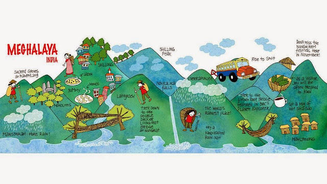
Creative travel map
Interesting travel map by 'They Draw and Travel' (TDAT)

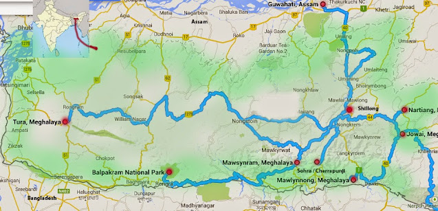
Map of main tourist attractions in Meghalaya
Tourist destinations in Meghalaya

LOCATION

Country: India
State: Meghalaya

'Megh' in Sanskrit means the 'cloud'  and 'Aalay' means 'abode'.

MAIN CITIES AND TOWNS (of tourist interest)

1. Shillong, the administrative capital of this state
2. Guwahati/Dispur, the capital of Assam is the main entry port of Meghalaya

HOW TO REACH 

By Air
Shillong has an airport, hence accessible by flights from Guwahati and Kolkata. Guwahati airport is about 2.5 to 3 hrs away from Shillong.

By Road
There are daily bus and trekker services from Guwahati. Trekker services run every half an hour from the Paltan Bazar bus station. Bus stations are at Paltan Bazaar, Khanapara, and ISBT. The ticket price is around 160.

By Rail
The nearest train station is also Guwahati. From Guwahati, one can opt for car rental, bus, or flight.

WEATHER and WHAT TO WEAR

Meghalaya enjoys a cool climate all year round. In summer, the afternoons may get a little warm but the weather can change drastically in seconds. The highest in a year can go up to 25 C and the lowest around 2-3 C. Monsoons get heavy rainfall almost throughout the day. 

The end of June to mid-July is not the best time to visit Meghalaya. It rains continuously and there's heavy fog with almost zero visibility. One must carry an umbrella or raincoat in the monsoons. Warm clothes are a must all year round. 

A few clicks of Nohkalikai Falls
The Nohkalikai falls in June end, Early April, and July end

If one wishes to see the waterfalls in full flow, mid-July to August end is a good time. In peak monsoons (mid-June to July) the waterfalls are the best, but you have to get lucky with the fog! One of my visits was in June end, I could hear the waterfalls but could see nothing!! Winters are dry, hence the waterfalls are not as grand!

WHERE TO STAY and WHAT TO EAT

Usually, tourists base their stay at Shillong, Sohra, and Cherrapunji and travel around. Most of the places can be covered on day trips.  There are good hotels of all ranges. There are homestays as well in the smaller villages. My suggestion would be to base your stay at Mawlynnong village. It's a small village away from the city. Provides a peaceful retreat. The village is hyped as the cleanest village in Asia. It is definitely clean but I am not sure who ranked the city as the cleanest in Asia, nevertheless, it is a good place to stay. I preferred it over Shillong.

ACTIVITIES 

Trekking is the most popular activity in Meghalaya.

PLACES TO VISIT

Map of Meghalaya Hills
Hills of Meghalaya

Map of Waterfalls in Meghalaya
Waterfalls of Meghalaya

Reserve Forests, Wild Life Sanctuaries, and National Parks of Meghalaya

Living Root Bridges of Meghalaya. There are more than 100 + root bridges in the state and most of the known ones are in the Khasi Hills of which three are the most visited - Padu, Nongriat, and Riwai


3. Mawsynram, the wettest place on earth (Khasi Hills)


Saturday, October 11, 2014

Panna National Park, From Zero To Twenty Two

The Golden Camouflage - The Chital (Chitrala in Sanskrit meaning Variegated) or Spotted Deer. These are native to the Indian subcontinent only. They are widely seen in most forest reserves in India, Bangladesh, Srilanka, Bhutan and Nepal


And then the sun lit the world

We started for Panna National Park at 4ish in the morning in a Safari jeep shared with another couple, booked by the hotel we were staying at in Khajuraho. It was late November and pretty foggy. I wasn't carrying a jacket and the chill had almost gotten under my skin; almost to my bones ( idiom aside I meant it literally) but the anticipation of getting lucky this time to sight a tiger after several failed attempts before, kept the cold at bay.

We arrived at the park within an hour.  It was still dark when we passed through a dense deciduous stretch of Sal, tendu, acacia, bamboo, arjuna, and other trees I don't know the names of. The only wild creature I noticed was big yellow Nephila, the Golden silk orb weaver spiders (I think that's the species), resting in the center of their giant intricate arty webs. For once I felt even creepy arachnoids can be beautiful. My antique camera couldn't capture a very clear photograph in the bad light from a moving jeep. That's the umpteenth time I reminded myself, that it's time to replace my good old buddy of 10 years (I seem to hold on to the silly misconception that even inanimate objects have feelings).

As the jeep drove deeper into the forest, we could hear the rustle of trees suggesting animal presence but none came close enough to be sighted. Am sure the animals are well aware of the safari trails now and keep a safe distance. Sigh :(

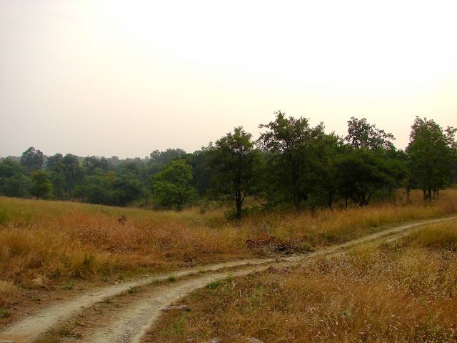
As if to complement the vermilion of the rising sun, the vegetation changed to a stretch of open dry grassland, a beautiful golden hue blanketing the earth. Impeccably camouflaged in that yellow lea were the first animals we saw, the golden spotted deer or chital as they are called in Hindi. Honestly, having seen deer so many times; even once, almost accidentally driven over one in Sioux Falls on my way to the badlands, I should have been more nonchalant but excitement surged in at the very sight of those elegant bucks, at least some animal on a tiger safari if not a tiger itself.


Moving on, the jeep re-entered a stretch of denser forest where we met some langurs and sambars but a tiger !!! nopes!! the guide said a tiger was sighted just the day before. Yes, that's what happens always, tigers are sighted the day before or the day after but not on the day. Someday perhaps!

On the safari trail
From Zero to Twenty-Two:

Parts of the Panna National Park originally belonged to the royal family of Panna. In 1981 it was taken over by the government for the conservation of the big striped cats. When counted in the early 2000s, the park had some 30-40 tigers but by 2009 the number shockingly dropped to zero. It was a huge blow for the Tiger conservationists and the park authorities. What caused such a catastrophe for the cats!? A report was published soon after thorough investigations of the shocking revelations, which suggested that some cats died a natural death after a 15-year life span, some were killed by the local villagers while protecting their livestock, some were poached by tiger smugglers, and some fell prey to revenge machinations of dacoits against local authorities. Additionally, the environmentalists blamed the diamond mines in operation in the region for endangering the tiger habitat. Ironically, most of the mines were shut down by 2009. The mining companies retaliated claiming the tigers died after the mines were shut down proving mines were not damaging the animal's habitat. The battle continued and all mines were ordered to shut down by 2016. 

Meanwhile, the park authorities decided to bring tigers from Pench to help breed them again at Panna. It was a risky proposition since relocation often causes emotional damage to the relocated animal. There was the danger of losing the relocated animal as well. The risk however was taken and it successfully paid off amidst many challenges. There is a heart-wrenching story about a relocated male tiger, who was so homesick that he walked almost 200 miles, halfway back to Pench before getting tracked by the Park authorities.  I wonder how helpless he must have felt on being brought back to a place he didn't belong to. Who knows what he was missing, who had he left behind in Pench, and why he wanted to go back. As animals, they cannot express their feelings and we take them for granted :( Well! eventually, the project of relocating the tigers worked for Panna, and currently, there are about 22 tigers in the park. A feat the park is mighty proud of :)

Back on the tiger trail
The effort is still on and Panna is doing a great job with better resources and hi-tech equipment that they didn't have years back. The major threat is the poachers and the local villagers and the park authorities have become extra vigilant to keep an eye on their 22 cats. Today, all the cats have radio collars, through which the forest guards and patrolling officers receive transmissions. A normal transmitter reading is 60 beats but if this reading drastically increases or decreases the tiger trackers get alert. They track the tiger through GPS and provide the required assistance. The trackers work 12-hour shifts. A couple years back two unmanned flying drones were also installed for tracking them.

Tiger conservation in India has definitely come a long way and successfully strode forward. Tigers habited 23 countries in the past but now they can be found in 11 countries only. Cambodia and Vietnam are the recent two countries to announce the extinction of this species from their forests. Laos, Thailand, Malaysia, Myanmar, Bangladesh, Russia, China, Nepal Bhutan, and Indonesia are the only remaining countries where tigers can still be found other than India which is the home of 70% of the world's wild tigers. These big cats need enough space food and protection from poachers to survive and multiply and this could be achieved in India because of extensive tiger conservation awareness projects, community participation, passionate conservationists, and forest officers and guards.

A well-spent afternoon by the Ken
As for us, we didn't see the striped cat eventually. Toward the end of the safari, we had a lovely time basking in the winter sun by the Ken River. There are options for boat rides also but we decided to head back instead; we were completely famished. On the way, we stopped at Ken Forest Lodge, very close to the national park for breakfast. The food was good and we even had an interesting chat with a young forest guide. A science graduate and an ardent animal conservationist who had come to Panna for a vacation from Bangalore fell in love with the place and decided to stay back at the lodge, as a forest guide. It's interesting to meet such passionate people for whom work and passion do not conflict. Who chooses to do what their heart chooses to do. Was truly inspired. From there we headed back on towards Khajuraho but took a little diversion to the enchanting Pandava Falls. A decision we didn't regret. I had plans to check out the Jhardova rock paintings as well but the driver couldn't locate them. Perhaps, giving us a reason to come back.

Long-tailed Hanuman Langur are Old world monkeys native to the Indian subcontinent
LOCATION:

State: Madhya Pradesh
Country: India

HOW TO REACH:

Panna National Park can be best reached from Khajuraho which has an airport and a railway station. The park is about an hour away from Khajuraho by car. One can hire a safari jeep from Khajuraho.


WHAT TO WEAR:

Light cotton is good since the weather is mostly warm. For winters a jacket is a must, especially if taking the early morning safari. 

WHERE TO STAY:

The park has its own resort. Plus there are other resorts close by. Many stay in Khajuraho.

Sambar is a large deer native to South and South-East Asia. Currently, it is on the endangered list due to hunting and habitat loss.

Thursday, October 9, 2014

Arunachal Pradesh, The Land Of The Dawn Lit Mountains

Tourist destinations in Arunachal Pradesh
LOCATION

Country: India
State: Arunachal Pradesh

Arun in Sanskrit means the 'first rays of the sun' or 'dawn' or the reddish hue of the dawn. Achal means 'mountains'.

MAIN CITIES AND TOWNS (of tourist interest)

1. Itanagar, the administrative capital of this state
2. Bomdila
3. Tawang
4. Ziro
5. Roing
6. Guwahati/Dispur, the capital of Assam is the main entry port of Arunachal.

HOW TO REACH 

One needs inner line permits to enter Arunachal Pradesh. The Inner line permits can be obtained from Arunachal Bhavan in Delhi, Kolkata, Shillong, Guwahati, Tezpur, Dibrugarh, and Lilabari. For Indian nationals the form + inner line permit fee is Rs. 5+ Rs.25. The application requires two passport-size photographs and a copy of Identity proof. All females married and single are required to provide a permission/no objection letter from their Father/Spouse/Local Guardian.

Address:

1. Resident Commissioner, Government of Arunachal Pradesh, New Delhi, Arunachal Bhawan, Kautilya Marg, Chanakyapuri, New Delhi.

2. Deputy Resident Commissioner, Govt. of Arunachal Pradesh, Kolkatta, CE-109, Sector-1, Salt Lake City, Kolkatta.

3. Deputy Resident Commissioner, Govt. of Arunachal Pradesh, Guwahati, Rukmini Gaon,  R.G. Baruah Road, Guwahati-781021.

4. Deputy Resident Commissioner, Govt Arunachal Pradesh, Shillong, Pin-793001, Meghalaya.

5. Deputy Resident Commissioner, Govt. of Arunachal Pradesh, Parvati Nagar, Tezpur, Assam.

6. Deputy Resident Commissioner, Govt. of Arunachal Pradesh, Mohanbari, Dibrugarh, Assam.

7. Deputy Resident Commissioner, Govt. of Arunachal Pradesh, Lilabari, North Lakhimpur, Assam.

By Air

The nearest airports to Arunachal Pradesh are:

1. Lilabari, Assam. Itanagar is about 2 hours from here.
2. Tezpur, Assam. Helicopter services to Tawang are available from here as well.
3. Guwahati, Assam
4. Shillong, Meghalaya

By rail 

Harmuty is the nearest railway station to Itanagar.
Other railheads close to the Arunachal border are Dibrugarh, Tezpur, North Lakhimpur, Jorhat, Tinsukia, and Guwahati.

By road

The final entry into Arunachal is by road. Either by buses or private/rented vehicles. Assam and Meghalaya is well connected to Arunachal through Bus services and Trekker services.

WEATHER and WHAT TO WEAR

Arunachal weather ranges from very cold tundra climate to tropical climate depending on the area being traveled to. The highest at the foothills in peak summer could go up to 40 C and the lowest at the foothills could go up to 15 C. At higher altitudes, it gets pretty cold even in summer. Monsoons are pretty much wet all across the state.

It is advisable to carry a mix of woolen and cotton when planning a statewide trip.


WHERE TO STAY and WHAT TO EAT

Most places in Arunachal have decent hotels and restaurants. In smaller villages the choices are limited. There are homestays and food mainly consists of rice, vegetable, meat, and fish.

ACTIVITIES 

Trekking, Site seeing, Scenic drives, boating, river rafting

PLACES TO VISIT

There are about 10 tourist circuits in Arunachal

1. Tenga, Bomdila, Tawang Ciruit via Guwahati and Tezpur 
2. Itanagar, Ziro, Daporijo, Aalo, Pasighat
3. Roing, Anini
4. Namdapha National Park via Margharita
5. Aalo to Mechuka
6. Ziro to Koloriang
7. Pasighat to Tuting
8. Seijosa, Itanagar, Doimukh, Segalee. Seppa
9. Daporijo to Siyum
10. Tezu to Hayuliang via Tinsukhia

STORIES

1. Mr. Bell