Friday, October 31, 2014

Cherrapunji / Sohra, The Wettest Place On Earth

On the way to Cherrapunji

As a kid, I had this strange obsession wanting to visit Cherrapunji having read about it in school as the wettest place on earth (the position has now been gracefully taken over by Mawsyngram). My grandfather was posted in Shillong, hence we often visited the then Scotland of East almost every summer (Shillong is not the same anymore), and each time I voiced my last wish as if it were so, to visit the land of oranges, as it meant in the native language. Reaching Cherrapunji then was no less than an adventure with bad roads and limited means of access much unlike today, Hence, that wish kept getting postponed year after year until my grandfather moved out of Shillong, and the Cherranpunji visit got stalled for years. Finally, in 2014 D day arrived, and I got the opportunity to visit Sohra, the old name of Cherrapunji that has been reinstated by the Meghalaya government.

Places of interest close to Cherrapunji


It was wet literally

It was more like God wanted me to experience what the kid me had wished for many many years back - the wettest place on this planet, though that wasn't exactly what I had in mind after growing up :P.  It drizzled the entire day with lucky sun breaks once in a rare while.

Cloud-covered lush green valleys

The fog had shrouded the entire valley. Even driving was getting risky at times, the road was only faintly visible most of the journey. At times when the fog lifted and the drizzle stopped, I would hungrily savor the lusciousness of the panorama in front of my eyes. Wow!! could anyone even imagine there was so much green behind all that white ?!?


Enchanting! Dreamy !! Surreal !!! I could sit there for hours just to stand and stare and then disappear into the next misty spell.


Nohkalikai waterfall

Luckily enough, I saw the Nohkalikai waterfall, the tallest waterfall in India. It wasn't in its best flow but still spectacular. The name Nohkalikai is associated with a tragic story.


Ka Likai who lived in Rangjyrteh, a village close to the waterfall, had a suspicious second husband. The man disliked her child from her first marriage. One day, when Ka Likai went to the forest to collect wood, her husband killed the child and cooked a delicious meal of her meat. He served it to K Likai when she returned hungry and tired. Without much thought she ate the food and turned to her husband, asking him what had he cooked? It was so delicious. The evil man smirked and said it was her child. The shock of the heinous deed and her own guilt of eating her own child turned Likai insane. Maddened she ran out of her house screaming for forgiveness and waving an ax at anyone who tried to stop her. She ran till the edge where the falls plunged off the precipice and threw herself along with the raging water. Ever since then, the fall has been called Noh Ka Likai ( from where Ka Likai jumped - Noh means jump in Khasi).


Site of the seven sisters waterfalls

The scene at the Seven Sisters, Nohsngithiang Falls was veiled in white. We could only hear the gushing water. The locals said to wait till the wind blew the mist away. We waited for hours but the curtain refused to rise to our greatest disappointment :(


A photograph of the Nohkalikai at a restaurant near the falls shows its full flow right after monsoons around July. Calls for a return.


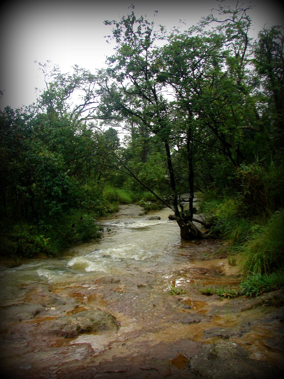
The same followed at the Mawsmai caves. We were told the water in the caves was pretty high, though many people still ventured in, so we decided to pass it. On the way, the fog had cleared a bit and we spent some time along this pretty streamlet. 


Not before long, the fog curtained the magical greens, blues, browns, and all the many colors with stark white, as if to say, "That's it for now! come back again for the whole movie, this was only a curtain raiser" Of course, I definitely shall! for so much was missed! :) At times I think, I can rechristen Sohra as Kohra (mist in Hindi) :P


Shillong And The Khasi Hills

Shillong is the capital of the Indian State of Meghalaya and the headquarters of its East Khasi Hills district. Nongstoin is the headquarters of the West Khasi Hills district. Shyllong, a local native deity, gives this City its name. Its old name was Yeddo and Lewduh. It was a favorite destination of the British when the East India Company occupied India. They found a climate similar to Scotland and called it the Scotland of the East. In 1874 after the formation of the state of Assam, Shillong was made its Capital. In 1972 after the division of Assam, Shillong was made a part of Meghalaya, and Dispur became the state Capital.

Hills of Meghalaya

Mary Help of Christians Cathedral

My mom grew up in Shillong and has very fond memories of the city. In my childhood, we spent many a summer in this beautiful city. Honestly, Shillong has changed a lot now. It was prettier when we were kids. Now it has grown and looks like any other City. The beautiful mountains are now covered with concrete and buildings. However, outside Shillong, much of Meghalaya is still untouched, unexplored, and free from urbanization which is in one way a blessing. Urbanization often ruins the natural ecosystem.

History of the Khasis

Legend of Origin

The Khasis are an indigenous tribe who probably migrated from southeast Asia (most likely from the great plains of the Mekong River in Cambodia) through Myanmar and Bangladesh and are of Mon-Khmer origin. The Khasis are said to be one of the first tribes to migrate to India. 

The origin of the Austroasiatic people is probably the great plains of the Mekong Basin including Laos and Cambodia. Khasic, Munda, and Nicobarese are the only three surviving Southern Austroasiatic languages spoken 

Legend has it that the Khasis are a direct descendent of Hynniew Trep (meaning 'seven huts' in Khasi) who was the equivalent of Adam in the Bible (the first human created by God). Hynniew Trep and his seven sons belonged to 7 of the 16 clans of Heaven (Khadhynniew Trep - Heavenly huts). They descended to Earth from Heaven through a sacred vine, located at U Lum Sohpetbneng called Khynriam Ka Brew Ka Bneng which meant the 'Golden vine bridge of heaven', a kind of living root-ladder-like bridge connecting Heaven and Earth. The 7 clans were called Ki HynniewTrep (people of seven huts) and their land was called Ri HiniewTrep (The land of the seven huts). The seven sons were Khynriam, Pnar, Bhoi, War, Maram, Lyngngam, and Diko (extinct now) who founded the seven Khasi tribes. However, many sociologists believe, that Khasis do not have sub-tribes but are classified by their place of habitat.

Ramew, Mother Earth, and Basa her husband were created by God (U Blei Trai Kynrad) as a part of the Universe. Over time Ramew felt lonely and requested God for company. God blessed them with 5 children in the form of Moon (son), Sun, Water, Wind, and Fire (daughters). Ramew and Basa were happy, yet there was emptiness since the beautiful garden of Earth nurtured by Ramew, Basa and their Children did not have anyone who could avail and enjoy this nature's trove. Realizing, the need, God then sent 7 of his clans to Earth. The remaining 9 clans remained in Heaven. However, God gave the condition that as long as the seven clans lived a righteous life, they could visit Heaven through the bridge but the day they chose the dark paths, the living bridge would wither and die and so it did when the clans began to fight among themselves and cut down a sacred tree at Lum Diengiei. 

The places formed by legends

The location of the seven huts

The Khasis like the Jaintias are matrilineal and matrilocal. The youngest daughter inherits the property and takes the responsibility of the family. In the absence of a daughter, the mother's youngest sister inherits the property and family responsibility. The surname is passed down by the mother and the groom moves to the bride's family.

The Khasis originally were nature worshippers and their religion was called Niam Tre or Niam Khasi. Later many converted to Christianity and Islam or adopted the Hindu way of life. 

Khasi Kingdom

The Khasi kingdom comprised 25 sovereign states (Hima) under 25 powerful Chiefs (Syiem). Later, many of these states were annexed by the Jaintia Kingdom. By the 19th century, the entire Khasi kingdom came under British rule and became a part of the Assam Province. In 1830, the Khasis led by Tirot Singh, the Chief of Nongkhalaw, revolted against the British but were eventually defeated after a four-year-long uprising.

The 25 Khasi States before independence
Places of interest

Places of interest in the West Khasi Hills that can be visited from Shillong as day trips. 

Places of interest in the East Khasi Hills which can be visited from Shillong as day trips

Places of interest within Shillong
Nonghum Island in West Khasi Hills

Aerial view of Weinia Falls from Google Earth

Kshaid Lanshiang falls view on Google Earth

Kshaid Thum and the beaches of Nongkhum Island (aerial view from Google Earth)

Green Deserts - Wah Rilang (Photograph source: Official Meghalaya Facebook Website)
Weinia Falls (Photo source: Official Meghalaya Tourism Facebook Page)

Makyrduk Monolith (Photo source: Official Meghalaya Tourism Facebook Page)

Makyrduk Monolith aerial view from Google Earth

Mawdohnud (Photo source: Official Meghalaya Tourism Facebook Page)

Mawdohnud, aerial view from Google Earth

Kyllang Rock (Photo source: Official Meghalaya Tourism Facebook Page)

Aerial View of Kyllang Rock from Google Earth

War's Lake, aerial view from Google Earth

Pamphyrnai Lake, aerial view from Google Earth

Lum Symper, aerial view from Google Earth

Dingding-Kohlangat Falls, aerial view from Google Earth

Double Root Bridge near Cherrapunji. (Picture source: Official Meghalaya Tourism Facebook Page)

Kynrem waterfall (Picture source: Official Meghalaya Tourism Facebook Page)

Aerial view of Kynrem Falls from Google Earth

Saturday, October 25, 2014

Meghalaya, The Abode Of Clouds


The living root bridge at Riwai Village near Mawlynnong
Creative travel map
Interesting travel map by 'They Draw and Travel' (TDAT)

Map of main tourist attractions in Meghalaya
Tourist destinations in Meghalaya

LOCATION

Country: India
State: Meghalaya

'Megh' in Sanskrit means the 'cloud'  and 'Aalay' means 'abode'.

MAIN CITIES AND TOWNS (of tourist interest)

1. Shillong, the administrative capital of this state
2. Guwahati/Dispur, the capital of Assam is the main entry port of Meghalaya

HOW TO REACH 

By Air
Shillong has an airport, hence accessible by flights from Guwahati and Kolkata. Guwahati airport is about 2.5 to 3 hrs away from Shillong.

By Road
There are daily bus and trekker services from Guwahati. Trekker services run every half an hour from the Paltan Bazar bus station. Bus stations are at Paltan Bazaar, Khanapara, and ISBT. The ticket price is around 160.

By Rail
The nearest train station is also Guwahati. From Guwahati, one can opt for car rental, bus, or flight.

WEATHER and WHAT TO WEAR

Meghalaya enjoys a cool climate all year round. In summer, the afternoons may get a little warm but the weather can change drastically in seconds. The highest in a year can go up to 25 C and the lowest around 2-3 C. Monsoons get heavy rainfall almost throughout the day. 

The end of June to mid-July is not the best time to visit Meghalaya. It rains continuously and there's heavy fog with almost zero visibility. One must carry an umbrella or raincoat in the monsoons. Warm clothes are a must all year round. 

A few clicks of Nohkalikai Falls
The Nohkalikai falls in June end, Early April, and July end

If one wishes to see the waterfalls in full flow, mid-July to August end is a good time. In peak monsoons (mid-June to July) the waterfalls are the best, but you have to get lucky with the fog! One of my visits was in June end, I could hear the waterfalls but could see nothing!! Winters are dry, hence the waterfalls are not as grand!

WHERE TO STAY and WHAT TO EAT

Usually, tourists base their stay at Shillong, Sohra, and Cherrapunji and travel around. Most of the places can be covered on day trips.  There are good hotels of all ranges. There are homestays as well in the smaller villages. My suggestion would be to base your stay at Mawlynnong village. It's a small village away from the city. Provides a peaceful retreat. The village is hyped as the cleanest village in Asia. It is definitely clean but I am not sure who ranked the city as the cleanest in Asia, nevertheless, it is a good place to stay. I preferred it over Shillong.

ACTIVITIES 

Trekking is the most popular activity in Meghalaya.

PLACES TO VISIT

Map of Meghalaya Hills
Hills of Meghalaya

Map of Waterfalls in Meghalaya
Waterfalls of Meghalaya

Reserve Forests, Wild Life Sanctuaries, and National Parks of Meghalaya

Living Root Bridges of Meghalaya. There are more than 100 + root bridges in the state and most of the known ones are in the Khasi Hills of which three are the most visited - Padu, Nongriat, and Riwai


3. Mawsynram, the wettest place on earth (Khasi Hills)