Monday, October 2, 2023

The Mysterious Garo Hills


Wari Chora in Garo Hills. Source of photograph: Official Meghalaya Tourism Facebook Page. One can reach Wari Chora from Baghmara. The Wari Chora homestay is about 1.5 hours by road. The trek point is an off-road drive of another 10-15 minutes. The descent trek is about 1-2 hours depending on one's stamina and ability to trek through forests. The ascent back is about 2-3 hours. The canoe ride and exploration at the canoe, waterfall, and river takes about 2-3 hours

Garo Hills are one of the most unexplored parts of our country. My father tells us stories of his adventurous trips to the beautiful caves and rivers hidden in these hills. The photographs I saw on the Meghalaya Tourism website are absolutely intriguing and I can't wait to visit these mysterious mountains. However, getting the permission to go there will be one big task. Till now my parents did not allow me to venture to that side rather scared me off it. According to them, it's pretty dangerous and unsafe. I googled a bit and yes, this part does sound difficult in terms of infrastructure (but I guess as long as development does not reach there, these hills will remain gorgeous) and insurgencies. People have been abducted and the tribes in these areas can be pretty intimidating for outsiders, I guess (However, I may be wrong since I have been mostly discouraged from traveling to that part of the country). Can't blame them! As has happened in other parts of the world, the tribes were uprooted from their very homeland in the name of development like one of the Khasi groups called Diko are extinct. Guess, it will take a while to figure out how to reach the hidden sanctuaries of these hills before development encroaches on them to mutilate their existence. People have visited and am sure I can as well pretty soon. 

Karukol in Garo Hills. Source of photograph: Official Meghalaya Tourism Facebook Page 

Simsang River in Garo Hills. Source of photograph: Official Meghalaya Tourism Facebook Page 

Places of Interest in the Garo Hills

The course of the Simsang River. It has its origin in the Nokrek range, then flows down south into Bangladesh where it is called Someshwari

Origin of the Garos

The origin of Garos is not well documented due to unavailable resources. Garo's history has been passed on through generations orally in the form of stories and legends. Ancient Garo scripts are lost and in recent times, English is their adopted script. The little that has been researched about their origin, suggests that the tribes probably migrated from Tibet. The similarities in language and traditions incline towards the theory. Garo's consider Yak tails sacred which is prevalent in Tibet and regions where Yak's are found. However, Yak is not native to the mountains of Meghalaya or other Garo habitats which further supports the theory, that their ancestral trail must have led to Tibet. Many Garo legends suggest similar stories of their migration from far Northern mountains. Small Garo Villages along the river routes even in the present day, lean towards these migration theories.

Many historians believe different Tibetan tribes migrated to Garo Hills following the course of the Brahmaputra River. Some even detoured toward present-day Sikkim and followed the course of the Teesta River. It is suggested one of the first settlements of Garos was Cooch Behar. They were later driven out from there by the Koch rulers. They moved East to Jogighopa and then to Dalgoma. From Dalgoma they moved South to Garo Hills. 

Other historians believe the Tibetan tribes followed the Salween River from its source and moved towards Myanmar. There they followed the course of Chindwin and Irrawaddy Rivers to reach the Mandalay region of Myanmar where they settled down as farmers. Some tribesmen later moved west and crossed over to Dimapur. From Dimapur, some went North towards Northeast Assam and some went towards Garo Hills.

Probable routes of Garo Migration to Meghalaya from Tibet 
The name Garo was coined by the natives for the migrant tribes. The origin of the name Garo is unknown or rather obscure. Some say stepped farmers were called Gari which later changed to Garo. Some connect the name to Garuda tribes and some connect it to Gara-Ganching tribes. Originally the Garos called themselves Achik Mande which means the hill people. The indigenous Garos were nature worshippers and they followed a religion called Songsarek. In recent times, most Garos have converted to Christianity. 

Like the Khasis and Jaintias, the Garos are also matrilineal and matrilocal but not matriarchal. The family name and the property are passed on through a chosen daughter of the family. In the absence of a daughter, a daughter is adopted from the mother's sister's side. After marriage, the groom moves to the bride's family and takes over the responsibilities of the bride's family. The Garos are divided into five exogamous clans called 'chatchis' or 'katchis' - The Marak, The Momin, The Sangma, The Arengh, and The Shira. Each clan is further divided into several septs called 'Machongs'. Marriages are strictly prohibited in the same chatchi. However, in modern times, many just follow marriage prohibition within the same 'machong'. I think the prohibition in marriages within 'chatchi' should have been strictly followed since it prevents inbreeding and recessive genetic mutations in offspring.

There are about 12 sub-tribes of Garos based on their dialects and geographical location: Ambeng/Abeng, A.tong, A.we, Chibok, Chisak, Dual, Gara-Gaching, Koch, Matabeng, Matchi, Matchi-Dual, Megam, and Ruga.

Distribution of sub-tribes in Garo Hills

Shiju Bat Caves - Source of photograph: Official Meghalaya Tourism Facebook Page. One can reach Shiju bird sanctuary and caves from Baghmara in about 1.5 hours drive

How and when to travel to the Garo hills

I heard from travelers that it is not very easy to get to the caves, waterfalls, and canyons. Most places need a good amount of medium-range trek through deep forests full of leeches, animals, and insects. But I guess that's what makes it an adventurous treasure hunt. I remember trekking to Chitrakote Falls through the deep forests of MP with a tribal guide when it was undiscovered and unexplored. The beauty was exquisite. But now it's an easily accessible tourist spot and always crowded. The interest in the place has since faded. I sincerely feel Garo Hills need to be preserved, and protected and not made easy access! 

Garo Hills are one of the wettest places in India, rather entire Meghalaya as the name suggests is the abode of the clouds. Monsoons are a bad time to get here. June and July are an absolute no-no for Meghalaya. Rather June to October is the wettest in the state. People tend to go to the hills for a cooler respite during summer vacations, but if one is planning treks and hiking, summer may not be the best time. It gets a wee bit sweltry. Also, the forests are infested with leeches which gets worse during summers and monsoons. I enjoy winters in Meghalaya and the cool climate makes treks easier. however, if one does not plan treks and hikes, summer may be fine.

Most places of interest in Garo Hills can be reached from Tura and Baghmara. One can reach Tura and Baghmara via Shillong or directly from Guwahati, Assam which has the nearest airport and railway station to the Garo Hills. Nokrek National Park is about 2.5 hours from Tura. Balpakram National Park is around 1.5 hours from Baghmara. 


Monday, September 25, 2023

A Walk On The Bridge That Breathes In Riwai

This small village 90 km south of Shillong, the capital of Meghalaya came into prominence when a travel channel voted it as the cleanest village in India. However, our main interest was the living root bridge connecting Riwai and Nohwet villages, very close to Mawlynnong. Root bridges are unique to the state of Meghalaya and not seen in any other part of the country perhaps not even the world.


It took us about 3 hours to reach Mawlynnong from Shillong. The drive usually takes about 2hrs but we couldn't resist taking photo breaks in between. It was a beautiful March morning, with perfect weather, and an absolutely picturesque route. Many shades of green flanked both sides of the road for miles and miles till we arrived at a streamlet. 


Inspired by John Keats .... lingering along streams of rushing waters...in the heart of pristine nature, the blue skies, virescent trees, and cool breeze.....echoed our hearty laughter....:) :P (Okay that was a terrible effort and I hope Keats didn't turn in his grave - I owe an apology) :P


The loveliness of the tranquil ambiance can't be captured in photos for sure! It must be experienced, smelt, and felt. A painter's paradise, a poet's muse, a writer's haven, a singer's mood. 


Had we brought camping equipment, this would have been the perfect place to pitch the tent for the night. Not sure if it's safe at night but if allowed I would surely try the next time.


The multi-purpose cane basket. Here is an eco-friendly innovative trash cone. Isn't it cute? Mawlynnong and Riwai are eco-tourism community ventures and they have used only natural, biodegradable materials for the trash cans everywhere.


Off we went on the trail to the Living Root Bridge. As the name clearly implies, a living root bridge is an actual 'living' 'root' bridge :)  A bridge made of the roots of a living tree of the class Ficus Elastica - Banyan fig in this case.


In order to make the tree's roots grow in the right direction, betel nut trunks are used. The trunks are sliced down the middle and hollowed out, to create root guidance systems. The thin, tender roots of the ficus tree are led through the hollowed portion thus, preventing them from fanning out and allowing them to grow just straight. When they reach the other side of the river, they're rooted back into the soil. In time layers of roots form a strong sturdy bridge that can carry a good amount of weight. Once very strong, stone slabs are placed to make a smoother walkway.


It is said the bridges last for hundreds of years, depending on the health of the mother tree. Since new roots keep growing, the bridge literally regenerates every time the old roots or old trees die and over the years, its strength increases with more layers. Of course, villagers do maintain them well and are prompt about all repair work, since it's their only way to commute.


These bridges are the only means to connect to the small interior villages of Meghalaya which do not have road access. The trail to the Riwai Bridge is not too steep, slimy, or narrow as compared to many others.


Khasi men and women washing clothes along the beautiful stream. The same cane basket is used to carry the clothes.


A precarious little stretch of rocky trail. 


A typical bamboo and cane hut. Mawlynngong has homestays and guest houses for visitors. I think one must stay overnight to experience the place better since there are a couple of waterfalls and other nature treks, which can be enjoyed well if visited in leisure rather than a hurried and tiring day trip. Definitely a treat for those who like a little rustic, non-city atmosphere.


A tall bamboo tower leads to a sky-view shelter. The structure is at least 10-12 meters tall and made entirely out of bamboo, even the ties, and joints. Initially, I was a bit scared but once I began to trust the strength of the construction I eased up. The view from the top was spectacular. The feeling of being on a really high tree house can't be anything less than amazing.


There are even tree houses for visitors to stay in. Not sure how brave I will be to perch up that high for a night but shall give it a shot next time.


There are no restaurants in the village. The only options are homemade food and fruits offered by the villagers. We tried some new types of berries. Above: Shophie and below Shohsang. These berries looked quite tempting but ....but.... one bite and I literally jumped. It was extremely sour. I must have mimicked one of Jim Carry's favorite antics after an uncontrollable tickle ran through my entire body :P That's the best I can describe the degree of sourness. 


We didn't stay back for the night, as we had plans to go to Sohra for the waterfalls. But a promise I made to myself, next time I am going to carry a good fat book and stay there till I finish reading it. Fresh air and a good book should be quite relaxing. I think I should take 'Roots' :) 

Friday, September 15, 2023

The Untouched Jaintia Hills

From Tyrshi Falls, Jowai

The Jaintia Hills lie on the eastern side of Meghalaya. Jowai is the official headquarters of West Jaintia Hills and Khliehriat is the official headquarters of East Jaintia Hills. Jaintia Hills were a part of the Jaintia Kingdom. The Greater Jaintia Kindom spread across parts of the present-day, states of Meghalaya, and Assam in India and the present-day state of Sylhet in Bangladesh. Its winter capital was Jaintapura, in present-day Bangladesh, and its Summer capital was in Nartiang, present-day India. Later in 630 AD Jaintia king Raja Guhak (as per Wikipedia) divided the kingdom among his three sons - Jaintia Kingdom (present-day Meghalaya and Assam) went to Jayantak, Gour Kingdom (Northern Sylhet in Bangladesh) went to Gurak and Laur Kindom (another part of present-day Sylhet) went to Ladduk. 

What was the history of the Jaintia tribes is a bit of a contradiction. Some say they were an Austroasiatic tribe of Mon-Khmer Origins, who traveled to India from East Asia or South East Asia. Some say they were the origins of present-day Cachar or present-day Sylhet. I lean towards the former version considering the features and cultures of the Jaintias. 


As per some historians, a group of Mon-Khmer tribes traveled to the Kopilli Valley, from Tonquin (a region in North Vietnam) Via Yunan (a southwestern province of China), and Myanmar. They settled in the Kopilli Valley fed by the Kopili River. Later after the Indo-Aryan rulers took over this region under their reign and established the Pragjyotish Kingdom, the tribe moved west and north. Eventually, they settled in the region known as the Jaintia Hills.

The migration of Mon-Khmers from Tonquin to Kopilli Valley


The Kopili River Valley

The Jaintia kingdom went through many changes and rulers till the Britishers annexed it in 1835. One of the first known rulers of Jaintias was queen Urmi Rani. Jaintias are Matrilineal like the Khasis and Garos of Meghalaya. As the term suggests, the women carry forward the lineage, the surnames, and the inheritance. The youngest daughter of the family inherits the property. If the youngest daughter dies or is disowned, the immediate elder daughter inherits the property, and then her youngest daughter carries forward the inheritance. If there are no daughters in the family, the mother's youngest sister inherits the property and it continues in the same order. After marriage, the men move into the bride's family. Ancient Jaintia Kindom was ruled by Queen Monarchs. Women were powerful and highly respected.

Medieval Kingdoms of North Eastern India

The Jaintia matrilineal traditions continue even to the present day. Some Jaintias today are converted Christians and Muslims and some follow the Hindu way of living but the indigenous Jaintias worshipped nature their religion is called Niamtre and they follow three cardinal principals, Kamai yeh hok, tipbru tipblai, and tipkur tipkha which signify, honest living and livelihood, fulfilling duties for fellow humans, and all living beings, respect for the family.

Ruins of Jaintia KIngdom in Jaintapur in Bangladesh (Source: Wikipedia)

Jaintia Hills is a region still not destroyed by human activities. It is endowed with lush green vegetation, beautiful waterfalls, and crystal clear-water rivers. Some famous points of interest are Tyrshi Waterfall, Nartiang monoliths, Umngot River, and Thlu Amwi Waterfall among others.

Places of interest in Jaintia Hills

Tyrshi waterfall (picture source Wikipedia)

Nartiang Monoliths (Picture source wikipedia). These monoliths were erected by Jaintia rulers in honor of their predecessors. This collection of monoliths is perhaps the largest collection in any one place

Thlumuwi Waterfall (Picture source Wikipedia) This falls is famous for a stone footbridge built by the Jaintia rulers 

Umngot River (Picture source Wikipedia). The Umngot or Dawki River is famous for being one of the cleanest rivers in India

Friday, September 1, 2023

The Regnant Queens Of Egypt

Queen Nefertari with Horus, the Falcon head God (painting at Nefertari's tomb in Luxor)

Nefertari - The Deified Queen from the 19th Dynasty (13th century BC):

I visited Nefertari's gorgeous tomb in Luxor's Valley of Queens last January during my seven-day trip to Egypt. The entry fee was pretty steep and only a limited number are allowed entry per day. The tomb's exquisiteness is evidence that Nefertari. was no ordinary queen. Initially, I thought Nefertari was Nefertiti but the guide cleared my doubts regarding the same. Nefertari was the beautiful wife of Pharoah Ramesses II. In fact, her name means 'beautiful companion'. She was considered one of the most powerful royal wives who was highly educated, for those times. Ramesses II bestowed upon her one of the highest honors ever received by any Royal Consort. He built her a temple alongside the Sun Goddess, Hathor in Aswan, known as the temples of Abu Simbel today. 

Temple of Hathor and Nefertari at Abu Simbel. The entrance facade has colossal statues of Ramesses II and his deified Queen Nefertari

The temple of Abu Simbel was originally built on the second cataract of the Nile in Aswan which currently is submerged under Lake Nasser after the Aswan High Dam was built. To conserve the temple, it was relocated to another site on the western bank of Lake Nasser, now called Abu Simbel. 

The original Abu Simbel temples were relocated from Aswan to Abu Simbel

Interesting Fact: The name Abu Simbel was actually the name of a Nubian Boy who showed the mound under which the temple was buried to Swiss explorer Burckhardt. Burckhardt, however, was not successful in excavating the temple. It was Italian archaeologist and the pioneer of Egyptology, G. Belzoni who later excavated it. The site was named after the boy who discovered the site.

Nefertiti The Reformer Queen from the 18th Dynasty (1351-1336 BC):

The famous limestone bust of Nefertiti, currently displayed in Berlin Museum

Nefertiti was the wife of Pharoah Akhenaten. Her name meant "The beautiful one has come". Some say she ruled for a few years after the Pharoah's death before Tutankhamun took over the reign of Egypt. She is known for religious reforms in Egypt. Akhenaten and Nefertiti introduced monotheism in the earlier polytheist Egypt. They established The Sun, Aten, as their sole GOD. Some studies suggest she may have been Akhenaten's blood sister. Some researchers suggest she may have been the mother of Tutankhamun. However, the recent, discovery of a mummy in KV35 whose DNA matches that of Tutankhamun and Amenhotep III negates the former theories.

Hatshepsut - The Pharoah Queen from the 18th Dynasty (1479 - 1458 BC)

Hatshepsut is the only queen whose tomb is in the Valley of the Kings. She was considered the most powerful female Pharoah however, chronologically, she was the second female Pharoah after Queen Sobekneferu (12th Dynasty) or perhaps the third considering Queen Merneith (First Dynasty) may have been a Pharoah as well.  She was the consort of her half-brother Thutmosis II and daughter of Thutmose I. She became a regent to the two-year stepson Thutmose III post the death of her spouse. Eventually, after a few years, she established herself as the Pharoah in her own right and even assumed the dress code and traits of male Pharoahs. She changed her name to Maatkare (Maat - Truth, Ka - Soul, Re - Sun God) to affirm, that she like any other Pharoah could communicate directly with God. While her original tomb was destroyed several times and her mummy relocated by her predecessors, her grand mortuary temple at the Valley of Kings proclaims her power and position. She and her achievements were almost erased from the history of Egypt by her predecessors considering her reign was one of the most prosperous and attributing success to a woman ruler was not acceptable to some of them for political reasons. Ironically, she trained her predecessor Thutmose III to become a skilled warrior, a scribe, and a priest as expected of a thoroughbred Pharaoh. He in turn ensured her name was obliterated for reasons still unexplained. Yet after all, the attempts to wipe out the existence of this great woman, she stands today as perhaps the most progressive Pharoah Queen of Egypt, and as her befitting name, Hatshepsut means 'The foremost of nobel women' who expanded trade relations to as far as Punt, led many infrastructure projects, and patronaged many great temples and buildings like the Karnak Temple, Luxor Temple, Deir El Bahari, and many others.

Deir El Bahari - The mortuary temple of Hatshepsut at Luxor

Merneith, The first Regent Queen from the First Dynasty (31st Century BC)

Bust of Merneith. Photograph source: National Geographic website

Merneith whose name means 'The beloved of Neith (the Ancient Egyptian goddess of home and feminity)' was the consort of Pharoah Djet and mother of Pharoah Den. She reigned as the Regent when Djet died and her son Den was too young to take over the responsibilities of a Pharoah. Some historians debate She may have established herself as a Pharoah in her own right and thus may have been the First Pharoah Queen of Egypt. Some historians believe she was the second regent queen, after Neithhotep, who ruled as regent for her baby son Hor-Aha after the death of her spouse, the first Pharoah of Egypt Narmer.

Sobekneferu - The first Regnant Queen of Egypt from the Twelfth Dynasty ( 18th Century BC)

Bust of Sobekmeferu at Berlin Museum. Photograph Source: Wikipedia

Sobekneferu was the daughter of the Pharaoh Amenemhat III and the last Pharoah of the 12th dynasty. She is considered the first woman Pharoah of Egypt, considering there is no clear evidence of Merneith being a Pharoah. She ascended or usurped the throne of Egypt after the death of Pharoah Amenemhat IV, who may have been her spouse or half-brother, or both. Her name means 'Beauty of Sobek (the ancient crocodile god of Egypt).

Cleopatra VII - The most Celebrated Queen and the Last Pharoah of the Last Dynasty, The Ptolemaic Dynasty (69 0 30 BC)

Statue of Cleopatra VII in Altesh Museum. Picture source: Wikipedia

Perhaps, Cleopatra is the most famous and most celebrated Egyptian queen. For a very long time as a kid, I thought Elizabeth Taylor was the actual Cleopatra. Cleopatra was the last queen, the last regnant of Egypt. I am not sure why popularly the title of Pharoah is not associated with her but technically, she is also the Last Pharoah of Egypt before the Romans took over Egypt. She was the daughter of Ptolemy XII Auletes. Her name means 'The father loving godess'. After her father's death, she ascended the throne along with her brother Ptolemy XIII as a co-ruler. However, they did not get along and civil war engulfed the empire. Meanwhile, Triumvir Julius Caesar occupied Alexandria in the process of chasing his enemy Pompey who sought refuge in Egypt but was betrayed by Ptolemy III. Caesar's army defeated and killed Ptolemy III and established Cleopatra and Ptolemy IV as the joint rulers of Egypt. Caesar had a famous brief affair with Cleopatra till his assassination. Cleopatra had a son Caesarion with Caesar. Later Cleopatra married Triumvir Mark Anthony and they had two sons and a daughter. Cleopatra was highly ambitious and had plans to expand her empire to far south and north with the alliance of Mark Antony. Unfortunately, her dreams were squashed when Octavian / Augustus Caesar, Caesar's Nephew ascended the throne of the Roman Empire, rather laid the foundation of the Roman Empire. Octavian manipulated Anthony into marrying his sister Octavia as a political strategy which angered Cleopatra but she eventually steered the divorce of Octavia and Anthony brought him back to Alexandria and proclaimed her children as successors to her throne. This led to the final war between the Roman and Egyptian Army. The Egyptian army was defeated, and Anthony committed suicide. There are stories, that Anthony committed suicide on hearing the rumor of Cleopatra's suicide. Cleopatra was hiding in her tomb when Octavian took over Alexandria. Fearing her capture, she got herself killed by a snake bite and thus ended the 3200 years of Pharoah rule in Egypt.

Sunday, August 13, 2023

A Peripatetic In The Land Of High Passes

The Pangong Tso (Tso in the local language, Bodhi, or Ladakhi means lake)
ROUTE MAP OF LADAKH
LOCATION

Country: India
Union Territory: Ladakh

MAIN CITIES AND TOWNS (one must be acquainted with them to plan the itinerary)

1. Delhi, the Capital of India
2. Srinagar, Capital of Jammu and Kashmir
3. Leh, Capital of Ladakh
4. Chandigarh
5. Shimla
6. Manali

HOW TO REACH 

One can plan an itinerary of various combinations of flight, train, bus, personal/Hired vehicle, or treks.

By road
The route is marked on the map above.

Route 1. Basing Delhi as a starting point one can take the route via Manali, Keylong, and Sarchu to Leh.

Delhi to Manali: 574 Kms approx. takes anywhere between 9 hours, depending on the road condition.

Manali to Leh: 473 Km approx takes around 13 hrs, depending on the road conditions.

It is advisable to break the journey once at Manali and then at Sarchu.

Route 2: Basing Delhi as the starting point one can take a route via Chandigarh, Jammu, Srinagar, and Kargil to Leh

Delhi to Srinagar: 860 km and takes about 14 hrs in the best conditions.

Srinagar to Kargil: 204 Kms

Kargil to Leh: 234 Kms

It is advisable to break the journey once at Srinagar and then at Kargil.

By flight
The various airports on this route are:

1. Delhi (DEL) (International Airport)
2. Chandigarh Airport (IXC)
3. Jammu Airport (IXJ)
4. Srinagar Airport (SXR)
5. Shimla airport (SLV)
6. Kullu-Manali airport (KUU)
7. Leh Airport (IXL)


View of the Himalayas from the airplane on the way to Leh

I traveled to Leh via flight from Delhi and took me about an hour. From the airport, I joined two Japanese co-passengers to share a room at a local homestay. I was told it was one of the oldest homestays in Leh. Honestly, it wasn't great but it cost me just a couple 100 rupees and I was shocked that one could find accommodation for this price. I moved to a hotel the next day. It was not expensive either.

View of Leh Palace from the terrace of Old Ladakh Guest House

One word of caution: When traveling directly to Leh by flight it is advisable that one spends the first day at rest,  getting acclimatized to the altitude and pressure change. Leh is at an altitude of 3500 m (11500 ft) above sea level and hence lower oxygen level which causes breathlessness and altitude sickness that lasts for a few hours. There are healthcare workers who provide the required assistance in case of severe health issues. People with heart conditions and pressure problems should take the required precautionary measures. 

My Japanese roommates went out right after keeping their bags at the homestay for a city tour and came back pretty sick with breathing problems. They had to return back to Delhi the very next day. Hence, it is absolutely necessary to relax at the hotel on the first day and go out for site seeing only when you feel at ease.

By train
One can travel a part of the journey by train.

1. Delhi to Kalka and then the toy train to Shimla or take a bus or car to Shimla.
2. Delhi to Jammu

WEATHER and WHAT TO WEAR

Ladakh experiences extreme temperature variation. Peak summer could reach up to 35 C and peak winters can go as low as -30 C. I visited Ladakh in mid-July and stayed there till early October. The temperature was warm to pleasant. Some friends who visited in June mentioned that the weather was freezing cold at higher altitudes. Summer lasts between April and September end. Peak winter sets in around mid-November and stays till early February. The ice on the passes begins to thaw around March end.

The terrain is dry and dusty due to barren mountains and scanty rainfall. The sun can be extremely strong here. Cotton clothes with long sleeves, and a loose fit, are the most comfortable wear in this region. It is advisable to carry a warm jacket at all times cause the weather is unpredictable and it can get pretty cold even in peak summer. 

Sunscreens, sun shades, and closed shoes are absolute carry-alongs. If visiting monasteries it is preferred that one wears clothes that cover the arms and legs. No one openly objects but it is not considered respectable to expose. This dress code applies to both men and women.

WHERE TO STAY and WHAT TO EAT

There are luxury hotels to inexpensive guest houses in Leh. One can even find another traveler to share a room with. I think the minimum I spent was Rs. 300 for a room in one of the oldest guest houses in Leh and the maximum I spent was Rs. 600 at a small hotel near the city center market. Not the best rooms but good enough (according to me) for a night's stay! 


There are good restaurants and bakeries in the city center market. Leh is very small and any part of the city can be reached easily by walk. The main market was a 9-minute walk from the Old Ladakh Guest House. Later in the trip, I moved to a hotel in the market area.

Maggi was my staple diet in Ladakh for most days. Day 1 Dinner Maggi, Pineapple juice, munch, and orange wafer. It was 14th August and 'Indian Summer' was the perfect book to start that night.."When midnight struck in Delhi on the night of 14 August 1947, a new, free Indian nation was born. In London, the time was 8:30 p.m. The world's capital would enjoy another hour or two of a warm summer evening before the sun literally and finally set on the British Empire"

ACTIVITIES 

As mentioned above, Leh is quite small and one can easily access the main points of interest on foot. There are no public transportation facilities. At least there were none when I visited in 2012.

There are travel agents who can arrange vehicles for your sightseeing tours. One can also rent Motorcycles and cycles to travel around.

Main activities in the region, meditation at meditation centers, visiting monasteries, trekking, sightseeing trips to the lakes, and river rafting.

PLACES TO VISIT

Lakes

1. Pangong Tso - It takes almost a day to visit Pangong Tso from Leh and back but there are options to stay at Dhaba camp on the bank of Pangong and home stays at Spangmik Village but the availability is not guaranteed and the facilities are very basic. 

I went on a day trip to Pangong Tso with a group of local tourists on a jeep arranged by a local travel agent. We did not stay back, since we had plans to head for Nubra Valley the next day.


About to reach Pangong Tso

2. Tso Moriri - Traveling to Tsomoriri also takes an entire day if one wishes to come back to Leh but there are homestay options at Korzok village near the lake. Visit to Tso Moriri was also a day trip on a jeep. 


Tso (Lake) Moriri 

Valleys in Ladakh

1. SURU and ZANSKAR VALLEY
2. SHYOK and NUBRA VALLEY
3. DRAS and MUSHKOH VALLEY
4. INDUS VALLEY : 

The Indus Valley gets its name from the River Indus that flows through this region. The main attractions here are:

INDUS VALLEY ROUTE MAP


Confluence of Zanskar and Indus. In winter this gets frozen and adventure seekers and local travelers walk on the frozen river to Zanskar Valley down south. The trek is called Chaadar (sheet - sheet of ice) Trek
Day 1

Leh

The first day was spent resting, reading, and sightseeing from the terrace at the guest house. Leh is the administrative capital of Ladakh and the biggest city in the region. Most people base their trips at Leh. Major attractions in Leh include the Leh Palace and Shanti Stupa. 

On the way to Leh Palace


Day 2

Leh Palace was hardly a 5-minute walk from the guest house we were staying at. We went there on the second day. One can see the mud houses of Leh from the top floors of the Palace. From Leh Palace, I went to the local market and shopped for some handicrafts and also visited the museum. The Shanti Stupa was not very close, so I took a ride to it. From there, we headed back to the guest house. We were still getting acclimatized and hence were getting out of breath after walking a short distance.

View of Leh from Leh Palace


Shanti Stupa
Day 3

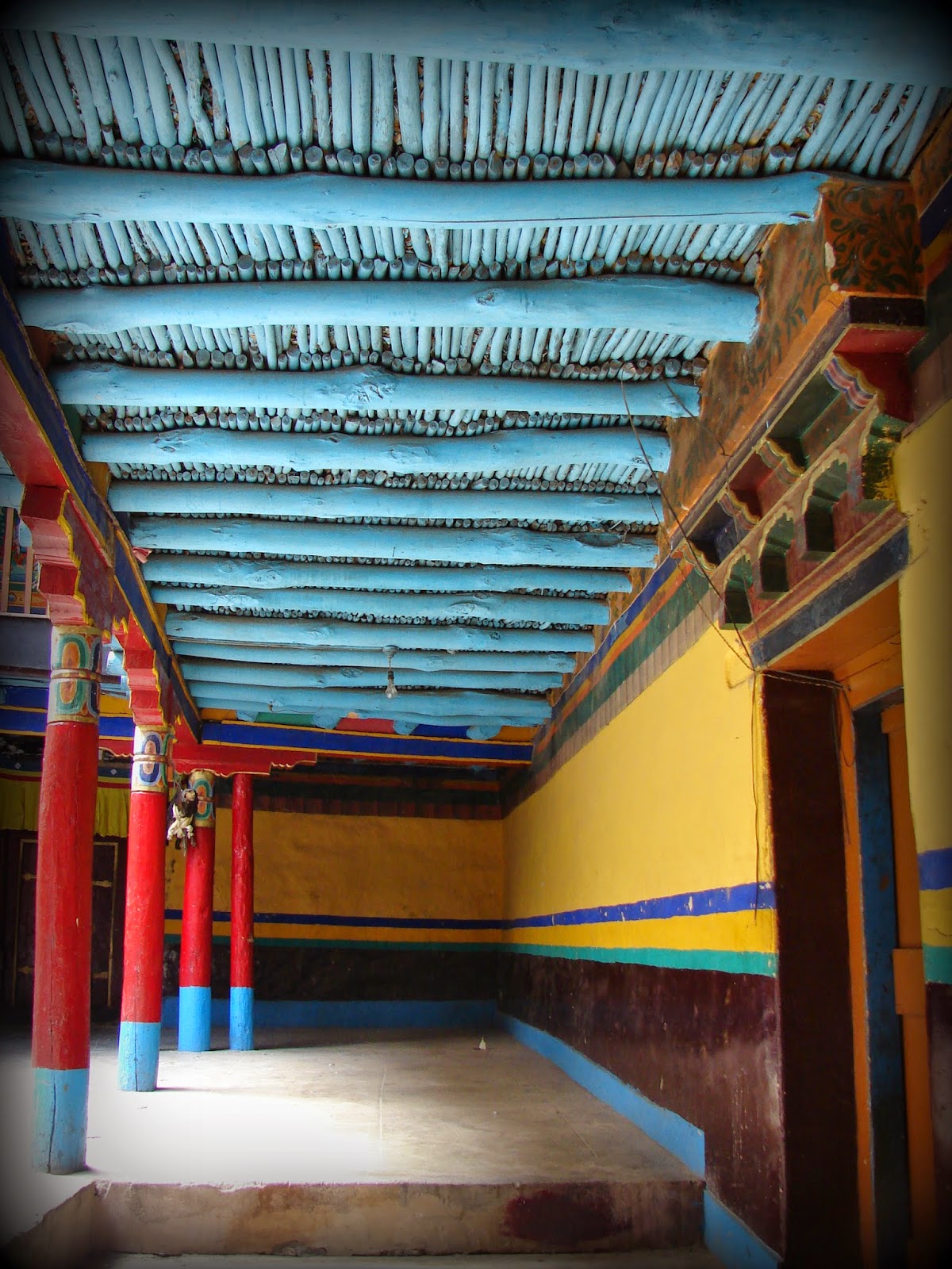
On the third day, we felt a lot better and decided to head for the monasteries. We booked a vehicle through a local travel agent we met in the market the previous day. He came along to guide us through the trip. He did tell us that there would be a lot of walking and we should proceed only if we felt fit and fine.  We were so fascinated by the monasteries and their architecture, that altitude sickness took a leave of us. We walked to every nook and corner of the monasteries which surprised the guide. He said most visitors just click a few photographs and head back, we were one of the few who went to every single room, floor, and corner of all the monasteries, and palaces we visited.

To the southeast of Leh are Shey, Stok, Thikse, Stakna, and Hemis monasteries. It might take a few hours to a whole day to cover this stretch depending on how enthusiastic one is to explore every nook and corner of the monasteries. 

We started early at 5:00 a.m. and reached Thiksey Monastery around 5:30 a.m. where the monks start the morning prayers by blowing long Tibetan horns/trumpets called Rag-dung

The travel distance from Leh City center is just 1 hr 35 mins but we spent the entire day exploring the palaces and monasteries and returned pretty late in the evening after participating in the evening prayers at the Hemis

The Shey Palace
The Thiksey Monastery
The Stakna Monastery

The Hemis Monastery

The Stok Monastery
Day 4

On the fourth day, we visited the monasteries on the northwest side of Leh, which include, Spituk, Alchi, Lamayuru, Likir, and Basgo monasteries among many others. My special mention would be Alchi. Beautiful wood carvings and amazing wall paintings adorn this gompa. On the way to the North West stretch, one may also visit the Nanak sahib Gurudwara which is considered a very sacred pilgrimage shrine for the Sikhs. The drive itself is scenic and it often feels like a painted landscape.

We started the day earlier on the fourth day and returned a lot later as well. Must Mention Lamayuru and Alchi took my breath away:)

5:00 a.m. morning prayer at Spituk Monastery

Flower offerings at Spituk Monastery

The Spituk Monastery

The Basgo Monastery

The Lamayuru Monastery

On the way to Lamuyuru, there is a stretch of rough badlands called Moonland

There is a stretch of land on NH1 called the Magnetic Hill where vehicles get pulled against gravitation. I was not convinced but I guess it happens cause everyone there said so :)

India's northernmost highway NH 1

The Likir Monastery

Gurudwara Patthar Sahib at 12000 ft above sea level is one of the highest Gurudwaras in the world