Friday, August 4, 2023

Where The Stars Meet The Sea


My interpretation of the memorable ferry ride in pencil

We decided to leave Koh Tao on an impulse. Can’t quite advocate unplanned ventures or adventures but more than often have gone that way! Undeniably, it has failed me a few times. Nonetheless, the apparent escapist in me said, that planning and then failing is more defeating than not planning and failing! Or better still an unexpected result, win or fail is perhaps more gratifying than an expected one. Well, philosophies aside, we elected to head south.

Sunset at Koh Tao. Koh (Island) Tao (Turtle) Turtle Island is a beautiful island in the Chumphon Archipelago in the Gulf of Thailand. It is much known for its Scuba diving resorts. Though small it is a nice getaway for 4-5 days with serene beaches, a colorful local market,  and decent eateries. 


A few many knocks on the doors of half a dozen travel agencies finally got us two last-minute tickets for the night ferry to Surat Thani. The ferry was a complete chock-a-block! 8 in the night the little port seemed alive with festive exuberance. There were few Thai natives and a swarm of enthusiastic young Western tourists. Most of them were in their early twenties, I presumed. I could hear the excitement and eager introductions going around. ‘Hiya! I am John from the UK..oh kool I am Monica from Switzerland. A German couple… A group of students from France. Wow! The world had just come to a small South Asian port at this hour of the night.

Our big bags were stowed away in the cargo section with number slips handed out and then we boarded in a queue (I make a particular mention of this pleasant word because it's such a rarity in my part of the world, unfortunately!). On the basis of first come first serve, some got the cabins with beds and I muttered in my mind ‘Jeez what a miss!’ only to realize in the next hour, that it was a miss worth well.  The next in the queue were given mattresses and pillows and the final last-minute-ers including us got coir mats and the invaluable instruction to find ourselves a place (if we can) to safely rest our butts!

We were on the topmost deck. It was clean though crammed with people, drinking, laughing, and merrymaking; seemed like a partying cruise. Scampering through the crowd and dodging the carefree passengers sitting on the deck floor with beer bottles in their hands, we finally managed to get ourselves to a strip of vacant space exactly in front of the engine room. 

What lay before us was the last railing protectively separating us from the endless starry sky and the endless gurgling sea - almost inviting us to dive into that seeming limitlessness. I wasn’t sure if the gooseflesh bespoke the chill breeze brushing against the skin or the hypnotic panorama in front of my eyes. We spread the mat, leaned against the backpacks, and wrapped the stole around. The chill had started to pinch. Yes! it wasn’t a dream.

Countless stars had irradiated the clear January sky. The sea was calm, the air bore the moist seaweed smell, and often times I could hear the waves splash against the ferry walls. Before long I was in a trance. For the next many hours, while time stood still, I sat reminiscing and reflecting on all the myriad moments gone past in the last many years. Maybe this is how close one can get to peace. A quarry we pursue so relentlessly to actually chase it away most often.


Suddenly, the ship's haunting horn blasted through the dead silence of the night interrupting my introspection. I could see distant lights moving….another ferry….carrying another traveler from another distant land to another distant destination.. who might be wondering quite like me, 'Perhaps this is where the stars meet the sky!'

Karst Topography In South Thailand

We came across Karst Caves on our 14-day Thailand and Cambodia trip itinerary to Thailand. We flew from Delhi to Bangkok. After a short trip to Cambodia, we headed to south Thailand. We stayed in Koh Tao for 5 days and then traveled to Phuket. While in Phuket we took a day tour of Phang Nga Bay. Here we came across some amazing Karst landscapes and caves. Ice Cream Cave particularly was spectacular.


Koh Tao to Phuket was almost a day journey. We took a sleeper boat from Koh Tao to Surat Thani - Our memorable sleeper boat ride from Koh Tao to Surat Thani. At Surat Thani Pier, we got a bus to Phuket. 


Phang Nga Bay tour was a day tour. We started early around 7:30 a.m. and came back around 5:00 p.m. We hopped a few islands in the bay and took a canoe ride to the Ice cream caves on Koh Panak Island


Phang Nga Bay has around 42 islands. The tour took us to Panak, Hong, and James Bond Island. The rest of the islands were cruised around


Phang Nga Bay Ice Cream Cave is a Karst formation. This Cave is one of the most breathtaking natural wonders of the world. When the Canoe entered the tiny cave, I did not for once imagine, it would eventually lead to an area open to the sky and surrounded by karst mountains covered in green foliage. It was a surreal experience 


Cave entrance in front. It looked so tiny from the outside but the surprise inside was overwhelming.


The Sinkhole formation: Open to sky enclosed within tall karst mountains. My photos do not do justice but the experience is uncapturable


Phang Nga Bay islands: Of the 42+ islands in the bay, 14 are the most visited which include Khao Phing Kan (James Bond Island), Koh Panak, Koh Hong, Koh Yao Yai, Koh Kudu Yai, Koh Panyee, Koh Nom Sao, Koh Raya ring to name a few. 'Khao' in Thai means 'hill' and 'Koh' means 'Island'.


What is Karst Topography

A Karst landscape is a formation in regions that have large deposits of limestone / or any calcium-rich stone, abundant water, and rich vegetation. Calcium-rich stone reacts with atmospheric CO
2 and carbon dioxide released by plants and aquatic organisms to form porous layers through which water seeps into the ground creating underground subterranean rivers, lakes, and caves with stalactite and stalagmites. These natural wonders are like sculptures designed by nature.


Stalactite in Phang Nga Bay Cave: Water-dripped mineral deposits that form icicle-like formations hanging down the cave roofs are called stalactite


Stalagmite and karst columns at Panak Islands: Stalagmites are icicle-type water-dripped mineral deposits formed on floors of caves. These grow upward and form columns when joined with stalactites growing downwards.


Stalactites- A closer look - water droplets can be seen on the tips


Karst columns - a closer look


Green fluorescent light in the ice cream caves due to the reflection of light through green algae water


Khao Phing Kan, popularly known as James Bond Island after the shooting of the 007 Movie, The Man with the Golden Gun


Ko Hong Islands


Prominent Karst Regions in Thailnd. Doi Nang Non is the karst region in the north. It became famous when 12 junior football team members and their coach got trapped inside one of the caves and were rescued over a 12-day period.

Karst landscape in Croatia


Friday, July 14, 2023

Gurudwara Sahib Teesri Udasi Near Tawang

Gurudwara Sahib Teesri Udasi, Tawang - Perhaps the second highest Gurdwara in the world at 13000 ft above sea level  after Hemkund Sahib in Uttarakhand 

We had no clue about the Gurudwara when we started out from Tawang towards Shungetsar Lake but it was not easy to miss. High up in the mountains, even in the mist, it stood out, almost inviting. It had a mystical allure. While it looks almost inaccessible, there is a motorable path up to a certain point, and then it's a long climb up the mountain to the shrine. Perhaps, this is also the only cave gurudwara built by cutting into the mountains away from the madding crowds - quiet and serene. 


Drive from Tawang up to the motorable point takes about an hour. The lake is about 30 minutes from there. Bum La Pass, one of the highest motorable passes in the world on the Indo-China border is about 30 km from here. The Gurudwara is maintained by the Indian Army.


The Udasis of Guru Nanak

Udasi means journey. In the 1500s Guru Nanak went all across the world to explore, learn, and spread his divine knowledge. His journeys are chronicled as the five Udasis or the five divine journeys. 

The first Udasi lasted for about 7 years and he went to various places including Benaras, Kamrup, Sialkot, and Nainital to name a few.

The second Udasi was for 7 years and this time he went south to Srilanka.

The third Udasi which lasted 5 years took him on a journey to Kashmir, Tibet, and Nepal among other places. He went to Tibet twice during those 5 years. On his way back from Tibet, he journeyed across to India through the route of Bum la Pass. It is said he spent many days in the mountains where the Gurudwara Teesri Udasi was built.

The fourth Udasi lasted for 3 years and this time he traveled far to Mecca and the Arabian countries.

The fifth Udasi lasted for 2 years. He spent these two years around Kartarpur and Punjab.

Source of information: link

It's a 200 m trek up to the Gurudwara


Shungetsar Lake

Thursday, July 13, 2023

How Were The Plitvice Lakes And Waterfalls Formed?


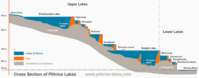
Plitvice Lakes: Tufa or Meteogene Travertine or Sedra (Croatian term): It is a porous variety of limestone deposits formed on waterbeds when calcium-rich water bodies create carbonates which form sticky layers on moss and algae present in the water. Over the years, these deposits form tower-like formations

Thermogene Travertine in Yellow Stone National Park

 Meteogene travertine (Tufa) vs Thermogene travertine

The main difference between meteogene travertine and thermogene travertine is that one is formed in unheated conditions and one is formed in a heated condition. Meteogene travertine is highly porous and spongy and is formed in cooler temperatures while thermogene travertine is less in porosity and needs very high temperatures for its formation. Meteogene travertine is a result of atmospheric and epigeal activities while thermogene travertine is a result of volcanic activities.

Source of image: Link The Plitvice region receives abundant rain feeding a continuous supply of water to the lakes and rivers which are rich in moss and algae which in turn supply carbon dioxide. The rich forest cover provides an abundance of oxygen which helps sustain life forms in the region. The Dolomite and Limestone rich soil supplies a high volume of calcium-rich ions. 

Process of Tufa creation

Ca++ (calcium ions in calcium rich water and soil) + H2O (water) = Ca(OH) (Calcium hydroxide)

Ca(OH)2 +CO2 (carbon dioxide from atmosphere and the aquatic life) = CaCO3 (calcium carbonate limestone / tufa) +H2O

In simple words, quicklime when mixed with water forms calcium hydroxide. This in turn converts to calcium carbonate when Carbon dioxide released by the aquatic organisms reacts with calcium hydroxide. The carbon dioxide released by the underwater organisms gets released to the surface in the colder seasons. The calcium carbonate deposits which are insoluble in water then start depositing on the moss and algae on the water surface eventually forming porous, spongy tufa. 

Tufa towers eventually form small tower-like structures creating barriers in the flowing water thus forming a series of lakes and waterfalls.

Karst in South Thailand

A landscape rich in tufa is called Karst. The main features of Karst topography are the abundance of soluble calcium in the form of limestone, dolomites, gypsum, etc,  clean water full of aquatic organisms and lifeforms, and a landscape with sink holes, fissures, underground streams, and caves.

Picture source: Link

Wednesday, July 12, 2023

Plitvice National Park And Its Legends


A: Veliki Slap Waterfall (The highest waterfall in Croatia at 78 m)  B: Korana River C: Sastavci Waterfall D: Novakovica Lake
The Legend of the Black Queen

Legend has it, the Plitvice Lakes were magically created by the Black Queen of Croatia. The Black Queen was a cruel, mean-spirited ruler, who reigned over the region a long long time ago during the dark ages. During those times, this region was fed by the Black River, and the forest surrounding it was called the Devil's Garden (Vražji vrt), inhabited by magical creatures. As the dark ages grew darker, a long, deadly drought dried up the river and brought the people to the feet of the Queen begging for water and life. For once, the Queen gave up her mean spirit, showed mercy, and magically created a large Lake, promising that it will never dry.  The Lake was named Proscansko after the Croatian word Prositi which means "beg for".


Schengen Visa:

As of January 2023, Croatia is an official member of the Schengen Countries and a Schengen Visa is required for entry to this country. We traveled to Croatia from Italy. More precisely, we were visiting Venice when we decided to head for the lakes in Plitvice, Croatia. We traveled to Italy from India on a multiple-entry Schengen tourist visa. Getting a Schengen Visa was not very difficult. It can be applied through VFS in Delhi. The VFS office is located at the Shivaji Stadium metro station. It took about a week between applying for the visa and receiving it. 


Mode of travel:

While there are multiple modes of travel to Croatia from Venice, we opted for the Bus. The bus ticket was booked online through Flix bus. We faced no issues getting the tickets, boarding, and traveling. The route was via Ljubljana, Slovenia. It took us about 5 hours to reach Zagreb.

The other options to travel to Croatia from Venice are, train, air, and ferry. While air travel is the quickest, it's the most expensive as well. Rail and waterway were long overnight journeys, hence we chose the bus.


Day 1: 

We were in Zagreb for a day. Our short stay was made deliciously memorable with freshly baked yummy pastries and a music festival, which we luckily got a chance to attend at the Zagreb square.

Day 2:

On day 2 early morning, we took another Flix Bus from Zagreb to Slunj. It took about 2 hours to reach Slunj. Zagreb has a good network of tram services and we didn't have any problem traveling around the city. Small tobacco stores near the tram stop/stations sell the tickets. When we traveled to Croatia in 2019, they were still using the Kuna as their currency. So, we exchanged some Euros at the bus station on our arrival the previous day. In January 2023, Croatia adopted the Euro as its official currency making life easier. 

Slunj is a small quiet quaint little town or maybe a village. I regret not planning a longer stay here. We booked a bread and breakfast here with a lovely river view room and lawn. I could have spent weeks here amidst nature's quiet beauty. Will share details of Slunj in another post.
 

Day 3:

On day 3 we booked a Flix bus to Plitvice Lakes. We waited at the bus stop at the said time, but the bus passed by without stopping to pick us up. We tried to enquire about the next bus or any other transportation options to the park but language proved a barrier since the locals were not well-versed in English. Most tourists travel to the park in rented cars or their own vehicles. After wasting almost 3 hours, we met a lady who understood English and helped us get another bus to the park. Our initial plan was to start early to avoid the afternoon sun. It was one of the warmest summers in Europe that year. Unfortunately, we started post 12:00 pm.

We finally arrived at the Lakes at 1:00 pm. The bus dropped us at the Ticket Office at entrance 1. They mentioned that the last bus left around 6:00 pm and if missed that, it might be a very long wait till late at night before we can get another bus. All restaurants closed around the time the park closed. There were very limited places of accommodation. This meant we had to ensure, we were back at the bus stop much before 6:00 pm since the buses here didn't quite follow the correct timings.

Entry Timings:

Summer timings (June and August) : 
7:00 am to 8:00 pm 
Last entry at 6:00 pm

Autumn/Fall (September and October) :
7:00 / 8:00 am to 6:00 / 7:00 pm 
Last entry at 4:00 / 5:00 pm

Winter timings  (November to March) :
8:00 am to 4:00 pm
Last entry at 2:00 pm

Spring timings (April and May) :
8:00 am -7:00 pm
Last entry at 5:00 pm

Ticket Prices are shared on the official website. Prices vary by season, entry timings, and age.


We entered the park around 1:00 pm and were out by 5:00 pm. We didn't want to risk missing the bus back but as a result, we skipped a few viewpoints and shorter treks. 

My suggestion is to pre-book the hotel at the park which is right across from the entrance 2 ticket office. It is a bit pricey and gets booked pretty fast in the peak summer season. Plan ahead and save the stress of missing buses. There are a few local taxis, at entrance 2, but they charge exorbitant rates.

The Lakes and the Waterfalls:

Must say the lakes, the waterfalls, and the park was gorgeous. All the trouble to get here was definitely worth it. 


There are about 8 trails that the visitors can take depending on how much they choose to see in a day. Details are available on the official park website. Since we planned a day trip and had wasted half a day thanks to the bus that ditched us, we opted for the C program with a slight change. Instead of going back to the starting point, we cut our hike short at ST2 and returned via entrance 2. We had to forgo some good views between St2 and Entrance 1. However, we managed to cover the entire park and took the boat ride on Lake Kozjak

I assume, starting the trek at entrance 2 is a wee bit better than entrance 1. Entrance 1 is close to the lower lakes and it's a climb all the way up to the highest lake, Proscansko. While from Entrance 2, it's a short climb to Proscansko and then a climb down to the lower lakes. 

Source of map: Official website https://np-plitvicka-jezera.hr/en/plan-your-visit/istrazite-jezera/activities/lake-tour-programmes/

The highest lake is at 637 m above sea level and the lowest lake is at 503 m above sea level 

Climbing up towards Lake Kaluderovac. The boardwalks are comfortable and safe. We went during peak summer when the boards were dry. They might get slippery during wet seasons.

Lake Kaluderovac at 505 m above sea level. The turquoise waters are clean and one can see the fishes and plants under water.

Lake Gavanovac at 514 m above sea level. Swimming is prohibited in the lakes. Water from the rivers and the lakes at the park is supplied as drinking water to the municipalities of Rakovica and Plitvicka

The Legend of the Gavanovo treasure

Local legends suggest,  at the bottom of Lake Gavanovac lies the hidden treasure trove of a magician named Gavan, after whom the lake gets its name. Gavan, the wizard had a treasure box of fairies and spirits with magical powers. Gavan was a kind and honest person and used this power for the welfare of his people but one day the Black Queen, heard about his treasure and sent her men to capture him. Fearing, the queen will misuse the powers, Gavan gave the box to his faithful servant Juraj and asked him to hide it in the deep forest. While escaping the Queen's men, Juraj fell into the lake releasing the fairies and the spirits. The fairies saved him, Gavan, and they kept the lake protected from the reach of the Black Queen. It is said the box still lies in the bottom of the lake and the fairies are heard singing in the stillness of the starry nights at the lakes.

Milanovacki slap Waterfall and Lake Milanovac at 524 m above sea level

Slapovi Milke Trnine Waterfall was named after Katarina Milka Ternina a famous Croatian Soprano (1863-1941)

Lake Kozjak at 535 m above sea level. It is also the deepest (47 m) and the largest (81.5 ha) lake in the national park. We took a boat from P1 boat point to P3 boat point. There is a rest area and a gift shop with ice cream and snacks near P1.

Veliki Pstavac Waterfall seen from Lake Burgeti at 545 m above sea level

Gradinsko Lake at 554 m above sea level 

Veliki Prstavac Waterfall (28 m high)

Milino Jezero Lake at 576 m above sea level

Galovacki Buk Waterfall and Galovac Lakr at 585 m above sea level
Bird's Eye view Picture clicked in 1937 Source: Link There are 6 small lakes between Proscansko and Galovac lakes at different heights. Vir at 500 m asl, Malo at 605 m asl, Veliko at 607 m asl, Baltinovac at 610 m asl, Okrugljak at 613 m asl and Ciganovac at 625 m asl

Proscansko Jezero at 627 m above sea level the highest lake. 
 
We took the shuttle back to entrance 2 from ST3 shuttle point near Proscansko. We were short on time, hence, chose to cut short a part of the trail between ST2 and Entrance 1. Perhaps will plan a visit in winter or fall. I heard the colors are grander in fall and the frozen lakes in winter are a surreal experience.